Where to find manual for the DRONE-APP...(not the construction of the Drone) Eachine 520 s

richg99

Active Member
The included manual has a section on the App's applications.

Nowhere do I see where to change things like the height the Drone goes to on its return home after using the RETURN key, or when power runs out.

My new bird starts rising well over 50 feet, up into the wind. Where I fly it, a height of 20 or 30 feet would be sufficient. Is there a LINK to something that would tell me if the Drone has the capacity to change its Return Height? Thanks, again.
 
RE: where to change things like the height the Drone goes to on its return home
1. When you hit the Return Home button, the drone will first automatically go up to a pre-determined height (altitude), then it will fly back above the spot it was launched, then it will slowly descend and land to the proximity of the launched spot.
2. The altitude it will go up before Return Home is pre-programmed. There is no option to change that.
3. It is pre-programmed with the idea it will minimize the possibility of slamming into a tree or building upon returning home.

RE: My new bird starts rising well over 50 feet, up into the wind
Never happens to me.
Did you use the left stick to launch the drone? If yes, that might explain it. Maybe you pushed the stick all the way up?
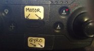
Use the button shown on the screenshot below indicated by the red arrow. The drone will go up about 10 feet and stay there.

e520s.jpg
 
Last edited:
Once again, you've answered my question. "The Return Home height can't be re-programmed. "...

As far as "rising to 50 ft"...I failed to say that....it happened when I hit Return Home,.....not when I started the first flight.

I watched a number of videos. One had the guy reprogramming the Return Home height, but that was on a different Drone. Thanks again for being there for us newbies. R
 
Yes. There are some GPS drones with option to change return home height.
Not this one.

As to "rise to 50 ft", I don't know why you have that issue. Perhaps in your case, use the left stick. Move the stick gently upwards until you have the height you want.
 
Last edited:
Thanks again. The immediate rise to 50 feet was only caused when I was in the "return to home" mode.

What I actually did was ..."turn off the transmitter " to simulate an "Out of Range" mode. When I realized that I'd rather not wait for the mode to complete its actions, ( pretty windy) I turned the transmitter back on and flew her down. If i had a very large open space, I'd have let her come down on her own. Thanks.... I'm learning.
 
Took her out and took my first pictures. I used the chip, as opposed to using my phone.

Not the sharpest shots (which is no surprise), but a fun "accomplishment" for this old codger. Even the video was watchable??? Ha Ha .

The picture is severely cropped. I have to learn to get the Drone closer for a photo session.
1st Drone shot cropped2.jpg
 
Ha Ha, I try to fly where there is NOTHING! in the way.

Some of the videos that I watch show guys in the middle of a desert. They put the Drone up, and if it came down a half-mile away, they could walk to it.

My limited choices here are soccer fields. They are often surrounded by tree lines.

The width of a soccer field is about 80 yards/70-meters...so, I might have 100 yards/90-meters of open area, in one direction. After that, as they said in the old (flat earth) sailing days...."Beware...There lie dragons". Ha Ha.

I am enjoying my new experiences. I wish there were some other elder-crazies drone flyers nearby.
R
 
Usually, you would set the landing/return area to the GPS settings you enter before flying. I guess some quads can home in on controller beacon, but most, as I understand, base the return location on the initial GPS settings instilled before launch. Otherwise you have a malfunctioning return function.
 
I didn't have an issue with the Location. My concern was that the Drone was set to rise far above the height I am used to flying. All is well. My particular Drone doesn't have a provision to change the "Return Home" height.
 
Works for me. Just don't be like the guy who sets his GPS landing point in a valley and then launches from the South rim of the Grand Canyon. H never found it again.
 
Ha Ha I live in Flatsville (Houston, TX). The highest point within 50 miles might be 50 feet. Trees are a much bigger concern since I lost my first (non-GPS) drone to them a week or two ago. R
 
Best place to fly them! I subscribe to a Bush Pilot's web site called "Angle of Attack" and they fly "real planes" in and around Utah, Nevada, Texas Panhandle and Oklahoma. They feel safe there and they do map out landing areas for their planes using quadcopters. Where I live in Southeastern Michigan, has water to fly over and not much open ground.
 
When one says Texas...we have to ask WHERE in Texas? It's 880 miles across using I-10. We have mountains, hills and more...just a little spread out. Ha Ha R.
 
Back
Top