jimcuviello
New Member
New Aerialtronics Altura Zenith RTF Agriculture NO Pix4D
Model # ZEN-ATX8-RTF-F002
Set Up Includes: Gimbal; GCS; PCS; Power package; Flight Case
BATTERY NOT INCLUDED
jim@cuvielloconcrete.com with questions or to make an offer.
The following information is accurate to the best of our knowledge. Potential purchasers should do their due diligence and to confirm specifics.
AERIALTRONICS
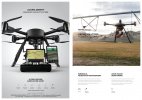
THE ALTURA ZENITH UAV. FLY TOMORROW’S INNOVATION TODAY
The Altura Zenith sets a precedent for the design of unmanned aircraft systems, by combining state of the art technology with remarkably flat, compact and lightweight design. Starting from scratch enabled the generation of a radically novel idea: developing a multi-rotor aircraft system that can meet a wide variety of application requirements without compromising on design.
UNIQUE DESIGN - BEYOND THE CUTTING EDGE
Performance and beauty are the cornerstones of the Altura Zenith. The structure was designed to enclose electrical components of the highest quality in a streamlined manner. Hidden within a super flat design, the Zenith carries a 10.000 or 20.000 mAh battery, which facilitates up to 35 minutes of flight time with total payloads of up to 1.2 kg for the ATX4 and 2.9 kg for the ATX8. All parts of the Zenith are carefully selected to form the best-balanced aircraft of today. Join the best, fly Zenith.
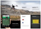
ALTURA GROUND CONTROL SYSTEM
The Altura Ground Control System (GCS) is one of a kind. All of its capabilities are featured on a simple overview to facilitate the control of the entire system. The pilot can manually control the position of the system and operate its payload with unparalleled ease. On an elegant tablet attached to the GCS the pilot operates our in-house app for autonomous navigation, waypoint triangulation and repetitive flight patterns.
ALL IN ONE - LIGHTWEIGHT, COMPACT DESIGN
All of the Zenith’s functions are easily controlled with the ergonomic design of the ground control station (GCS) and the GCS tablet app. This set up guarantees ease of use for an effective deployment of the Unmanned Aerial System (UAS). The operator can simultaneously maneuver the system and manage the GCS. All of the Zenith’s operations are within one simple touch
THE ALTURA GCS APP
Aerialtronics spends a lot of time optimizing system controls. The Altura GCS app manages both autonomous navigation as well as fully manual flights easily. Pilots can opt to navigate via waypoint or repetitive flight patterns. The interface is designed to enable flying for everyone within a couple of hours of training.
AIRCRAFT TELEMETRY & STATUS
The Altura GCS app provides a detailed overview of the aircraft status such as location, battery info and GPS
PHOTOGRAMMETRY & MAPPING
Easily pre-define flight grids, after launching the Zenith, software takes control, navigates and takes pictures according to grid.
AUTOMATE WITH WAYPOINTS
Fly autonomously along pre-defined flight paths and independently gather the required data
AIRCRAFT HEADING LOCK
This mode will cause the Zenith to remember which direction is “forward” so you don’t have to worry about the aircraft heading during flight
FLYING MODES - DOG MODE & FOLLOW ME
The Altura Zenith autonomously follows and films you when carrying GPS enabled GCS tablet.
VIRTUAL FENCE & SAFE ZONES
The Zenith can be flown within its virtual shelter of which it can’t leave the virtual pre-defined flight radius or maximum altitude.
AUTO TAKE-OFF & LANDING
Do not worry about take-off and landing. It is now possible to precisely start, take-off and land the Zenith by a flick of a switch
AIRCRAFT CONFIGURATION
The Altura GCS app enables you to adjust functions such as payload settings, cruise-speed, max-altitude and flight distance.
MANUAL CONTROL
Pilots can manually adjust the flight direction, cruise speed and have full control on all payload features from the ground.
GPS ASSISTED FLIGHTS
The pre-programmed switches allow the pilot to switch between various flight modes, such as GPS/Altitude hold, coming home and landing.
AIRCRAFT TELEMETRY & STATUS
The RF controller is provided with an build-in LCD status monitor, which provides you with the most important aircraft status information
PAYLOAD OR CAMERA CONTROL
Pilots can remotely adjust the payload tilt and panning angle and have full control on all payload features from the ground at the same time.
SPECIFICATIONS
Propellers 8 X 16”
Brushless Coaxial Motors
LED Color Direction Indicators
Quick Release Battery Tray
3K Carbon Fiber Construction
Battery 22.2V - 20.000 mAh
Length 23”
Width 23”
Tall 19”
Weight 14.66 lbs.
Payload Capacity 6.61 lb. Max
Take Off Weight Drone and Payload 21.27 lbs.
Range .62 miles
Max Cruise Speed 44.73 mph
Average Cruise Speed 11.18 mph (adjustable)
Wind Conditions 35.79 mph.
Model # ZEN-ATX8-RTF-F002
Set Up Includes: Gimbal; GCS; PCS; Power package; Flight Case
BATTERY NOT INCLUDED
jim@cuvielloconcrete.com with questions or to make an offer.
The following information is accurate to the best of our knowledge. Potential purchasers should do their due diligence and to confirm specifics.
AERIALTRONICS
THE ALTURA ZENITH UAV. FLY TOMORROW’S INNOVATION TODAY
The Altura Zenith sets a precedent for the design of unmanned aircraft systems, by combining state of the art technology with remarkably flat, compact and lightweight design. Starting from scratch enabled the generation of a radically novel idea: developing a multi-rotor aircraft system that can meet a wide variety of application requirements without compromising on design.
UNIQUE DESIGN - BEYOND THE CUTTING EDGE
Performance and beauty are the cornerstones of the Altura Zenith. The structure was designed to enclose electrical components of the highest quality in a streamlined manner. Hidden within a super flat design, the Zenith carries a 10.000 or 20.000 mAh battery, which facilitates up to 35 minutes of flight time with total payloads of up to 1.2 kg for the ATX4 and 2.9 kg for the ATX8. All parts of the Zenith are carefully selected to form the best-balanced aircraft of today. Join the best, fly Zenith.
ALTURA GROUND CONTROL SYSTEM
The Altura Ground Control System (GCS) is one of a kind. All of its capabilities are featured on a simple overview to facilitate the control of the entire system. The pilot can manually control the position of the system and operate its payload with unparalleled ease. On an elegant tablet attached to the GCS the pilot operates our in-house app for autonomous navigation, waypoint triangulation and repetitive flight patterns.
ALL IN ONE - LIGHTWEIGHT, COMPACT DESIGN
All of the Zenith’s functions are easily controlled with the ergonomic design of the ground control station (GCS) and the GCS tablet app. This set up guarantees ease of use for an effective deployment of the Unmanned Aerial System (UAS). The operator can simultaneously maneuver the system and manage the GCS. All of the Zenith’s operations are within one simple touch
THE ALTURA GCS APP
Aerialtronics spends a lot of time optimizing system controls. The Altura GCS app manages both autonomous navigation as well as fully manual flights easily. Pilots can opt to navigate via waypoint or repetitive flight patterns. The interface is designed to enable flying for everyone within a couple of hours of training.
AIRCRAFT TELEMETRY & STATUS
The Altura GCS app provides a detailed overview of the aircraft status such as location, battery info and GPS
PHOTOGRAMMETRY & MAPPING
Easily pre-define flight grids, after launching the Zenith, software takes control, navigates and takes pictures according to grid.
AUTOMATE WITH WAYPOINTS
Fly autonomously along pre-defined flight paths and independently gather the required data
AIRCRAFT HEADING LOCK
This mode will cause the Zenith to remember which direction is “forward” so you don’t have to worry about the aircraft heading during flight
FLYING MODES - DOG MODE & FOLLOW ME
The Altura Zenith autonomously follows and films you when carrying GPS enabled GCS tablet.
VIRTUAL FENCE & SAFE ZONES
The Zenith can be flown within its virtual shelter of which it can’t leave the virtual pre-defined flight radius or maximum altitude.
AUTO TAKE-OFF & LANDING
Do not worry about take-off and landing. It is now possible to precisely start, take-off and land the Zenith by a flick of a switch
AIRCRAFT CONFIGURATION
The Altura GCS app enables you to adjust functions such as payload settings, cruise-speed, max-altitude and flight distance.
MANUAL CONTROL
Pilots can manually adjust the flight direction, cruise speed and have full control on all payload features from the ground.
GPS ASSISTED FLIGHTS
The pre-programmed switches allow the pilot to switch between various flight modes, such as GPS/Altitude hold, coming home and landing.
AIRCRAFT TELEMETRY & STATUS
The RF controller is provided with an build-in LCD status monitor, which provides you with the most important aircraft status information
PAYLOAD OR CAMERA CONTROL
Pilots can remotely adjust the payload tilt and panning angle and have full control on all payload features from the ground at the same time.
SPECIFICATIONS
Propellers 8 X 16”
Brushless Coaxial Motors
LED Color Direction Indicators
Quick Release Battery Tray
3K Carbon Fiber Construction
Battery 22.2V - 20.000 mAh
Length 23”
Width 23”
Tall 19”
Weight 14.66 lbs.
Payload Capacity 6.61 lb. Max
Take Off Weight Drone and Payload 21.27 lbs.
Range .62 miles
Max Cruise Speed 44.73 mph
Average Cruise Speed 11.18 mph (adjustable)
Wind Conditions 35.79 mph.